
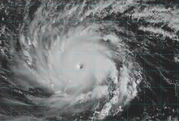
An unusual cluster of three tropical cyclones has formed across the Pacific, with forecasters warning that exceptionally warm ocean temperatures are providing favourable conditions for the development of powerful storms.
Hurricanes Lowell, Karina and Marie have been observed simultaneously swirling across the Eastern and Central Pacific, an uncommon occurrence that last took place in 2015 during another El Niño year.
Lowell and Karina are forecast to strengthen to category 3 or 4 intensity, while Marie could approach category 3, according to forecasts, the Mirror reported.
Lowell is expected to pass close to, or just west of, Hawaii as a major hurricane early next week. Karina and Marie, by contrast, are forecast to remain over open water and are not currently expected to pose a direct threat to land.
The development of the three systems comes amid elevated sea surface temperatures in the tropical eastern and central Pacific associated with El Niño, a recurring climate phenomenon in which ocean temperatures rise above their long-term average.
Warmer waters can provide additional heat and moisture to the lower atmosphere, helping to reduce atmospheric pressure and create conditions in which thunderstorms can become organised around a rotating centre.
🚨 LOWELL CHARGES NORTH: Hurricane Lowell is continuing its charge North toward the Hawaiian islands with dangerous impacts expecting on Kauai. FOX Weather is continuing to monitor and cover this storm from all angles, including from above. Stick with us all day today and join… pic.twitter.com/V3bFCvYbgK
— FOX Weather (@foxweather) September 6, 2026
The resulting systems can intensify rapidly when atmospheric conditions remain favourable, with warm ocean water acting as an important source of energy for tropical cyclones.
The simultaneous appearance of three hurricanes echoes the 2015 Pacific hurricane season, when Hurricanes Kilo, Ignacio and Jimena were active across the region at the same time during another strong El Niño period.
The current systems nevertheless present very different risks depending on their trajectories. Lowell’s projected passage near Hawaii is being closely monitored, while Karina and Marie are expected to remain away from populated areas over open ocean.
The strongest storms could reach major-hurricane status. Category 3 and 4 hurricanes are defined by sustained winds of at least 111mph (178km/h) and can cause extensive damage, including widespread power outages and the destruction of trees and other infrastructure.
The concentration of powerful storms over the Pacific provides a striking illustration of how changes in ocean temperatures and atmospheric conditions can create an environment conducive to rapid tropical cyclone development.
For now, the principal focus is on Lowell’s forecast track as it approaches Hawaii, while the other two systems continue to develop over open water.


Leave a Comment