

Centuries-old rarities come to London for Frieze Masters
Frieze opens to the public in London tomorrow (Wednesday) with two glorious fairs.
Frieze London is, of course, among the world’s most renowned contemporary art fairs, taking place each year in Regent’s Park.
Its sister fair Frieze Masters is just a short stroll away, and also takes place on 15-19 October 2014, but focuses instead on historical art through “a contemporary lens”.
This year, for the first time ever, Frieze Masters will feature a rare books and maps dealer: Daniel Crouch Rare Books.
Some of the maps it’ll be showing are truly magnificent – relics of how we used to view the world around us that tell incredible stories.
It’s little wonder that they’re priced in the tens or hundreds of thousands.
Here are some of the rarest and most beautiful maps that’ll be on display (and for sale) at Frieze Masters from tomorrow:
George Willdey and Thomas Jefferys, ‘A Free-standing Atlas of Europe’, London, c. 1750, £70,000

Source: Daniel Crouch Rare Books
This work is a four-fold screen, with 21 hand-coloured copper-engraved maps and was made in London, c. 1750. It is particularly exciting as it is exceptionally rare to find atlases in this form. There is only one other example of this particular screen map and it lives at the British Library, so it is all the more exciting that its ‘twin’ is now coming to the market.
Pieter and Johannes Blaeus, ‘Pascaarte van alle de Zee-custen van Europa’, from 1677, £600,000

Source: Daniel Crouch Rare Books
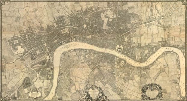
John Rocque, 24-sheet ‘Map of Georgian London’, 1737-46, £40,000
Source: Daniel Crouch Rare Books
Rocque was a French Hugenot émigré who arrived in London in 1730 and by 1737 he applied his surveying skills to the great task of surveying the entire built-up area of London. Begun in the March of 1737, upon a scale of 26 inches to 1 statute mile, the map would take nine years to produce, eventually being engraved upon 24 sheets of copper and published in 1746. The plan stretches west to east from Hyde Park to Limehouse and north to south from New River Head to Walworth. Daniel Crouch Rare Books will offer this at Frieze Masters for £40, 000.
Hendrik Doncker, ‘Pascaerte van Oost Indien…’, from 1664, £320,000
A rare sea chart from the Dutch Golden Age.

Source: Daniel Crouch Rare Books
Willem Janz Blaeu, ‘West Indische Paskaert… Gedruckt t’Amsterdam Bij Jacobus Robyn, inde Nieuwe Brugh steeg inde Stuurman’, from c.1630/1674

Source: Daniel Crouch Rare Books
Find out more at friezemasters.com and crouchrarebooks.com.
Love the London art scene? Read on…


Preview – Constable: The Making of a Master at the V&A
John Nugent: There’s no downside to live music in the cinema

Leave a Comment